Infrastructure
Flood resilience infrastructure is complex and costly, so options must be carefully prioritised based on risk reduction, affordability, feasibility and community benefit.
North Gisborne has experienced significant flooding in recent years, including severe impacts on 28 February 2023 when an intense localised thunderstorm caused sudden and widespread damage to homes, streets and infrastructure. In response Gisborne District Council is investigating flood resilience improvements to reduce risk to life, protect critical infrastructure and support community resilience and insurability.
The North Gisborne Flood Resilience project focuses on flood risks across the Mangapapa, Matokitoki - Valley Road area and Whataupoko near Central School.
This phase is nearing completion and includes updating hydraulic models (last updated in 2014, which show similar patterns), assessing how flooding occurred in February 2023 and other severe weather events, identifying stormwater and overland flow constraints, understanding impacts on properties and infrastructure and assessing potential mitigation options.
The assessment used updated flood modelling, analysis of Cyclone Gabrielle impacts and future climate scenarios to better understand flooding behaviour and risks. Flood risk varies across each neighbourhood - with different flooding mechanisms and constraints identified in Matokitoki, Mangapapa and Whataupoko.
Flood resilience infrastructure is complex and costly, so options must be carefully prioritised based on risk reduction, affordability, feasibility and community benefit.
Total flood mitigation costs for North Gisborne are estimated at over $100 million.
Allocation project funding is $15m, including $2m for investigations and concept design.
No final decisions have been made on preferred options or future delivery – staff are currently workshopping the prioritisation with the final decision to be made at a Council meeting on 25 June.
Funding availability, staging and affordability will be important considerations in determining next steps.
Mitigation options not funded through this project will be promoted for inclusion in the Long Term Plan or Infrastructure Strategy, which set out priorities and direction over the next 10 and 30 years.
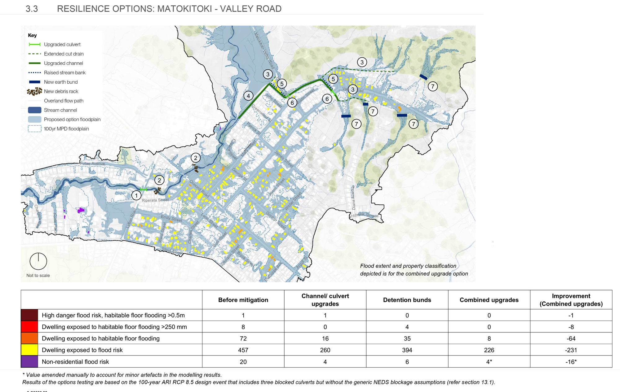
Investigations confirm that flood risk issues in North Gisborne are primarily due to there not being space for floodwater to pass safely through the urban area.
Investigations show these upgrades would reduce flood risk for the greatest number of properties, while upstream debris racks can help prevent blockages.
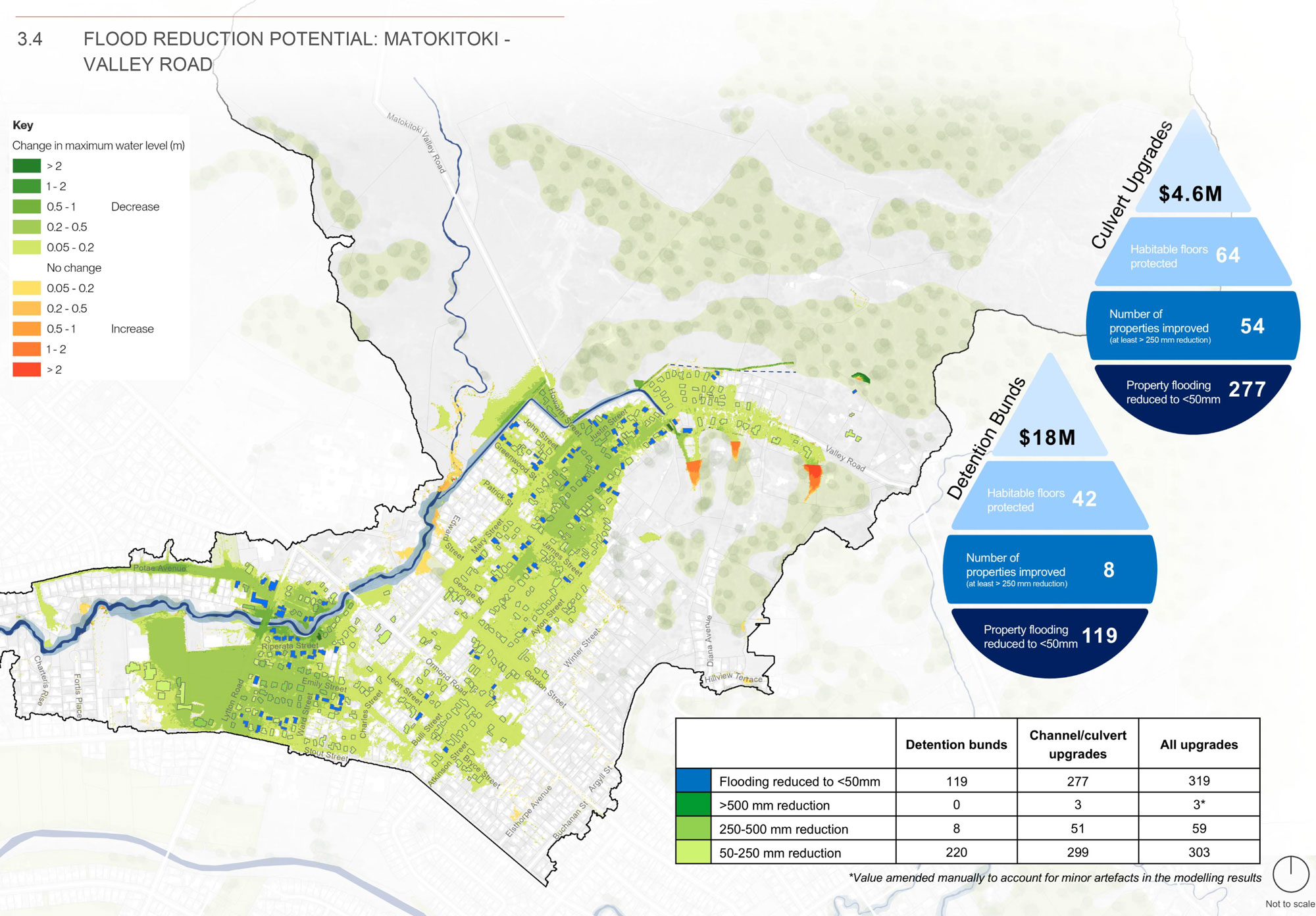
This area has some of the highest flood risk in North Gisborne, but there's strong potential to reduce impacts.
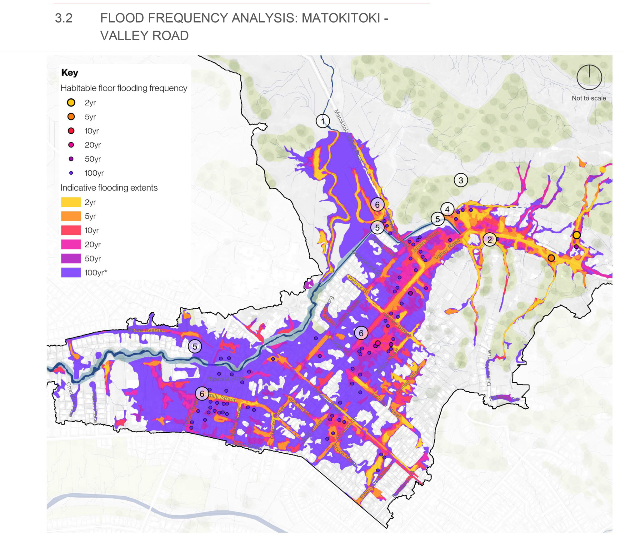
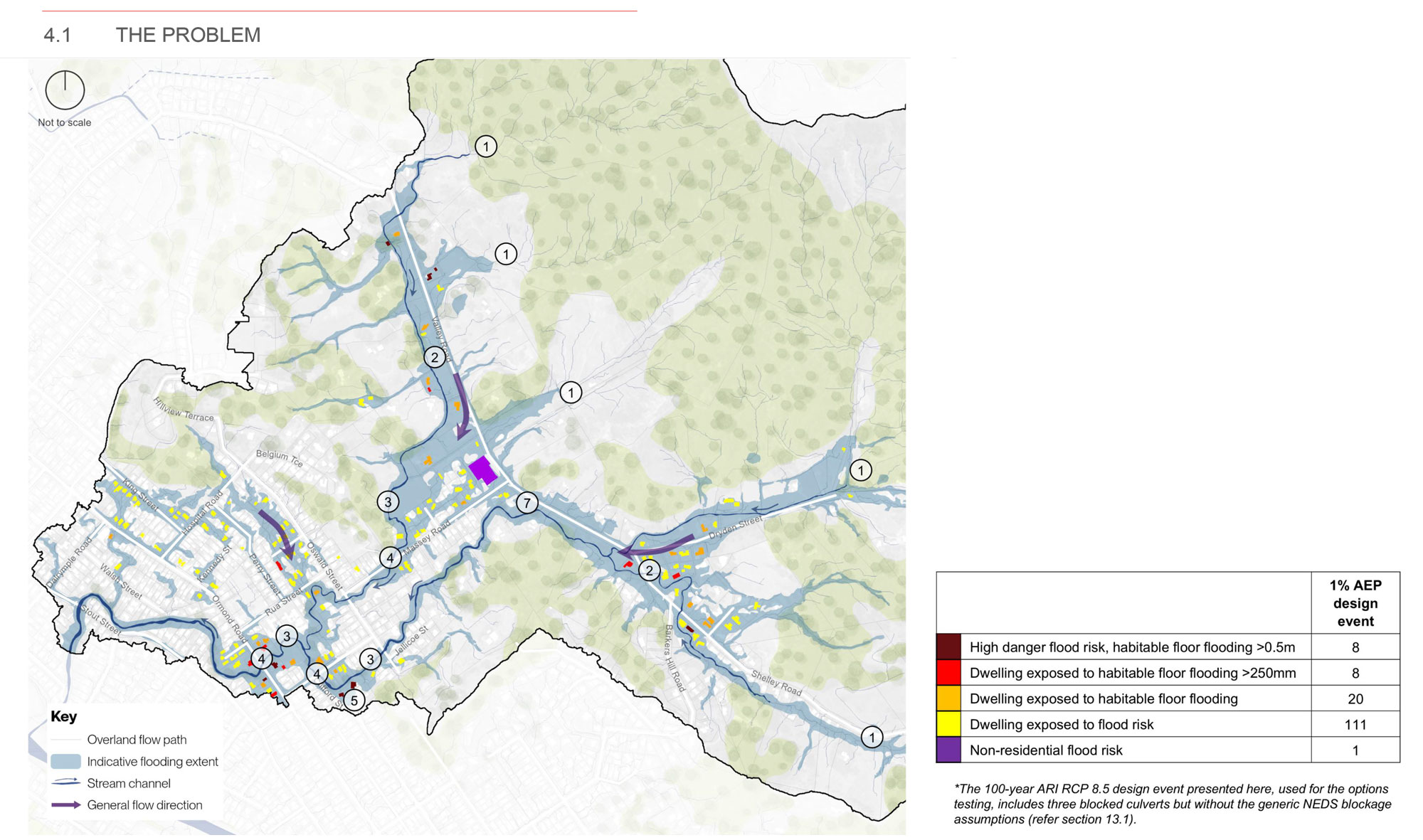
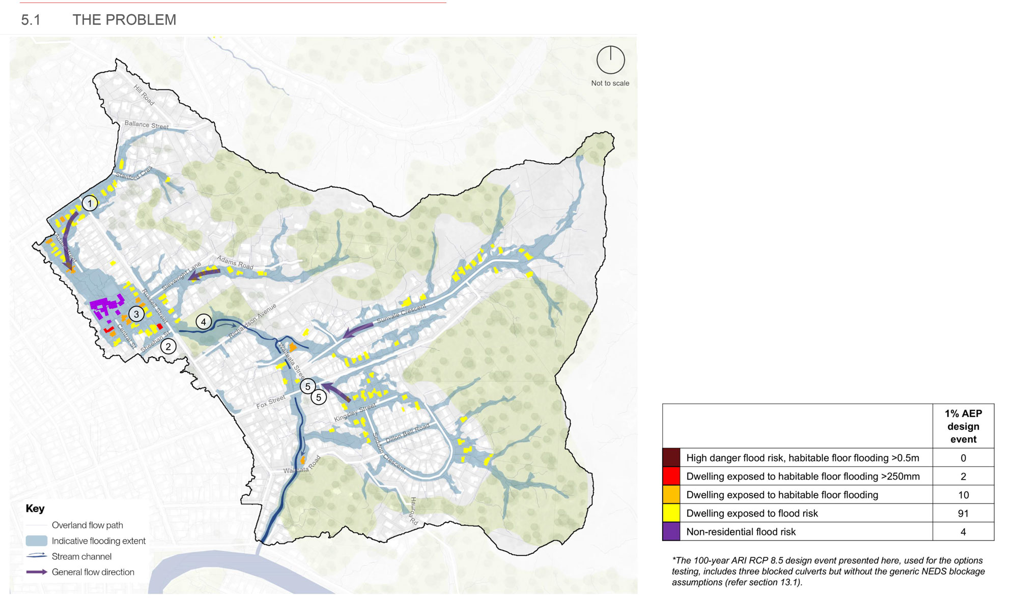
Analysis of the modelled 100-year ARI design event* helps with understanding the flooding mechanisms that cause problems in the Matokitoki – Valley Road catchment:
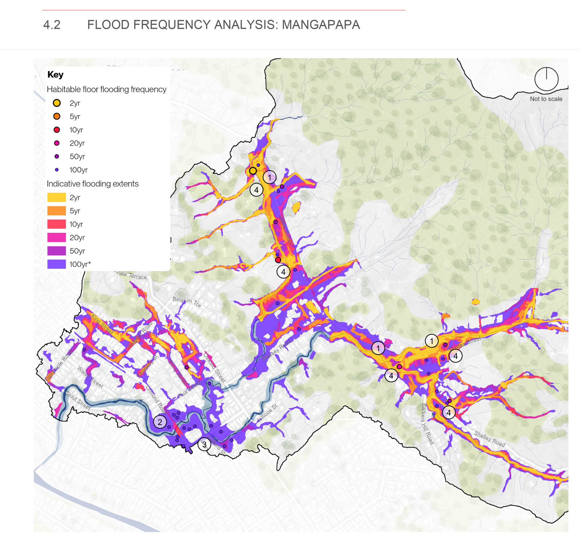
Analysis of a range of different return period events helps to understand how frequently the identified problems (section 2.1) may occur. The coloured dots indicate the smallest/most frequent event where potential habitable floor flooding is predicted. 20-year and 50-year ARI events predict the same number of properties to be effected which is why 50-year ARI dots appear to be ‘missing’ from the figure.
*The 100-year ARI RCP 8.5 design event presented here includes three blocked culverts and the generic NEDS blockage assumptions to understand the full extent of the potential flood risk (refer section 13.1).*
ARI (Annual Return Interval) describes how likely a flood event is — for example, a 100-year ARI event has a 1% chance of happening in any given year.
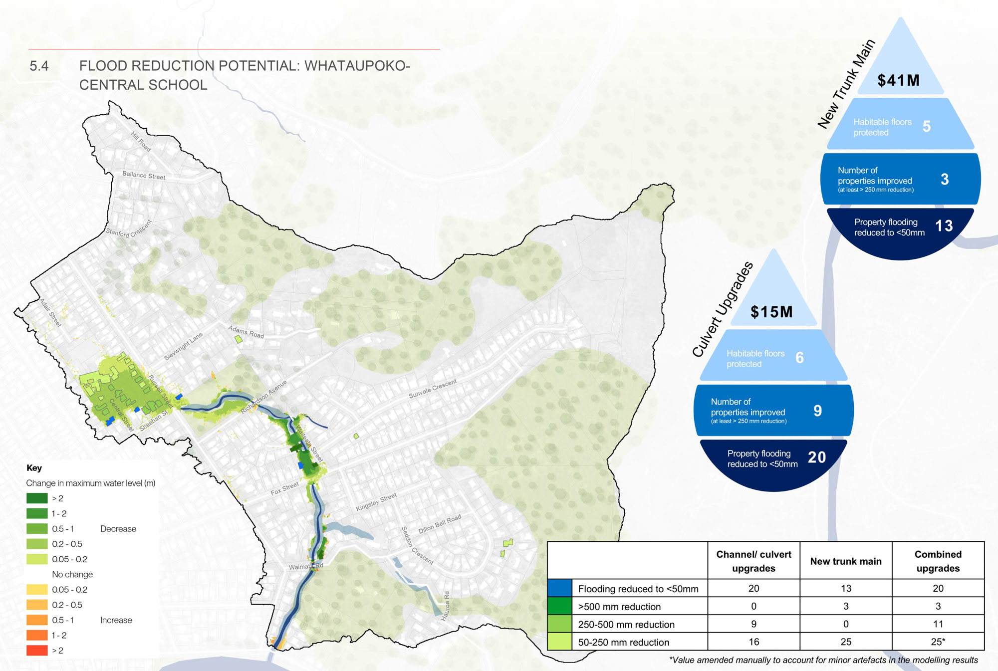
The proposed solution and associated benefits include:
North Gisborne flood impacts and resilience options. It includes property impact assessment, options costings and more details.
Investigations show there are limits to what infrastructure upgrades alone can achieve in this area. Regular maintenance, reducing stream blockages and using a mix of approaches will all be important to help reduce future flood risk in this area.
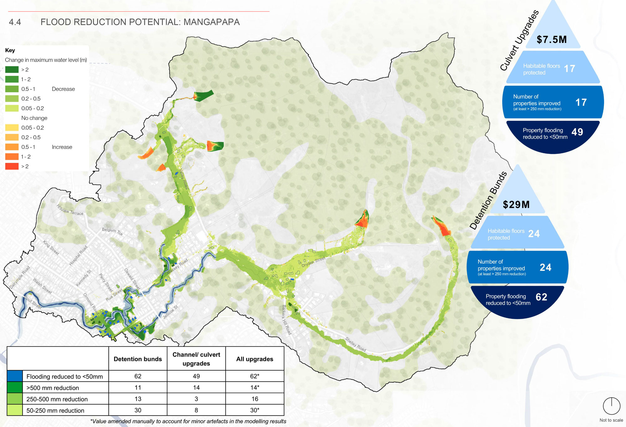
Analysis of the modelled 1% AEP design event (see section 11.1 in the report) helps with understanding the flooding mechanisms that cause problems in the Mangapapa catchment:
AEP (Annual Exceedance Probability) describes the likelihood of a flood each year—for example, a 1% AEP event has a 1% chance of occurring in any given year.
Analysis of a range of different return period events helps to understand how frequently the identified problems (section 3.1) may occur. The coloured dots indicate the smallest/most frequent event where potential habitable floor flooding is predicted. 20-year and 50-year ARI events predict the same number of properties to be effected which is why 50-year ARI dots appear to be ‘missing’ from the figure.
The 100-year ARI RCP 8.5 design event presented here includes three blocked culverts and the generic NEDS blockage assumptions to understand the full extent of the potential flood risk (refer section 13.1 in the Report).
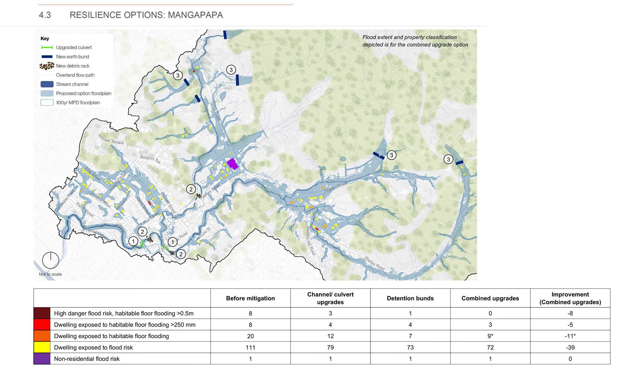
The proposed solution and associated benefits include:
North Gisborne flood impacts and resilience options. It includes property impact assessment, options costings and more details.
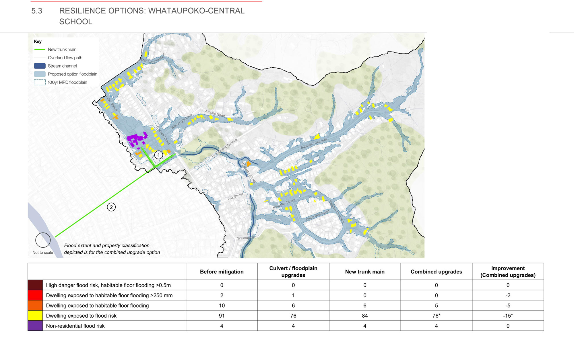
The Whataupoko-Central School area is low-lying, with many properties built in flood-prone areas and no natural overland flow paths. As a result, the area relies heavily on stormwater pipes and water levels in the nearby stream to manage runoff.
During heavy rain, when this system becomes overwhelmed, water has limited places to go, increasing flood risk to surrounding streets and properties.
Investigations show solutions in this area are complex and costly.
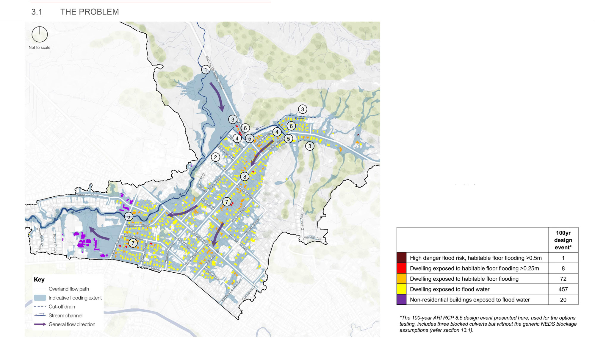
Analysis of modelling shows several key factors contributing to flooding in this catchment:
Analysis of a range of different storm events helps to understand how frequently the identified problems (section 4.1) may occur.
The coloured dots indicate the smallest (most frequent) event where potential habitable floor flooding is predicted.
In some cases, 20-year and 50-year events predict the same number of properties to be affected, which is why 50-year results dots appear to be missing from the figure.
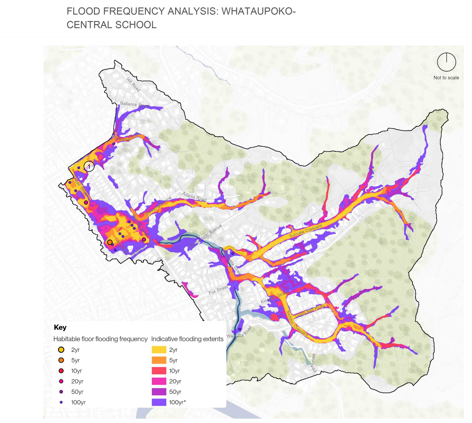
The 100-year ARI RCP 8.5 design event presented here includes 3 blocked culverts and the generic NEDS blockage assumptions to understand the full extent of the potential flood risk (refer section 13.1)
ARI (Annual Return Interval) describes how often a flood event is likely to occur on average - for example, a 100-year ARI event has about a 1% chance each year.
RCP 8.5 is a high climate change scenario used to model how flooding could be worse in the future due to more intense rainfall.
The proposed solution options and associated benefits include:
North Gisborne flood impacts and resilience options. It includes property impact assessment, options costings and more details.
We're keen to hear from residents, property owners and anyone affected or interested about the findings and proposed resilience improvements options.
Ask a question and our team will respond, or share your feedback, suggestions and photos by pinpointing a location on the map below.
You can also tell us if you're interested in a community session by completing the poll before Wednesday 17 June.
Ask a question and our staff will respond, or share your ideas, concerns or suggestions.
To ask a question you must create an account or log in.
These are the people that are listening and responding to your questions.
{{question.description}}
![]()
Have questions or want to learn more about a project, contact us below:
| Phone | 0800 653 800 (24 hours) |
|---|---|
| service@gdc.govt.nz | |
| Website | www.gdc.govt.nz |
| In writing | 15 Fitzherbert Street |