The Taruheru River Pathway will provide safe walking, cycling and wheeling connections along the awa, linking neighbourhoods and supporting both everyday travel and recreation across Gisborne.
A partnership to progress the pathway
Gisborne District Council and Tapuwae Tairāwhiti Trails Trust are working in partnership to progress the pathway as a safe, accessible route for the community.
A joint steering group - including mana whenua, Council staff and trust representatives - has confirmed the preferred route, benefits and delivery approach through a completed a business case.
Why it matters
The business case identified:
- Strong community benefit and a return on investment - $13.50 for every $1 spent.
- Nearly half of Gisborne’s population lives within easy reach of the pathway.
- Supports healthier lifestyles, lower transport costs, improves wellbeing and stronger community connections.
Council endorsement
On 12 March 2026, Council endorsed:
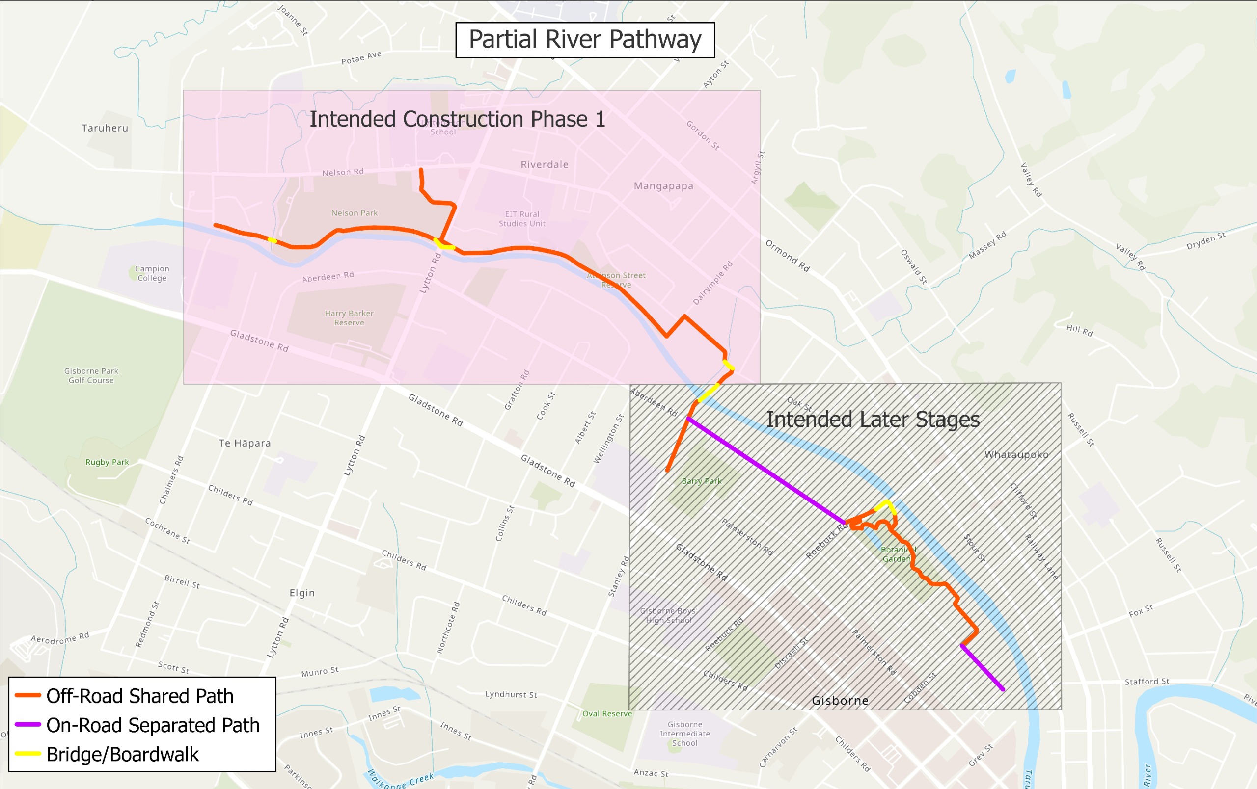
- The preferred route - Partial River Pathway from Derby Street to Campion Road.
- A flexible, staged delivery approach.
- Continued work to secure external partner funding.
The confirmed route shows where the pathway will generally run. Exact alignment and surface treatments will be refined through design development and community consultation.
Proposed construction Phase 1 section
This section has been identified as the most deliverable with current funding while providing strong early benefits.
What's happening next
- Design scenarios will explore layout options, extent and surface treatments (such as concrete and limestone).
- Connections to nearby schools will be considered through design development.
- Options will be tested through funding, design and community consultation.
Design scenarios will be shared for community feedback later in 2026.
Later stages will be developed once external funding becomes available.
Map of the Partial River Pathway and proposed Phase 1
The Partial River Pathway is a 4.5km route comprising a mix of on-road and off-road shared pathways.
The highlighted section shows the proposed Phase 1 route.
Exact alignment, surface treatment and extent will be refined as design progresses and community feedback is received.
Updated mapping will be shared here, along with opportunities for you to have your say.
Get involved – stay informed, have your say
We want the community involved in shaping this project, so we’re hearing from the right people at the right time.
👉Click the +Follow button to:
- Be notified when design scenarios are released and consultation opens.
- Stay up to date as funding options are explored and next steps confirmed.
- Make sure you don’t miss opportunities to have your say.
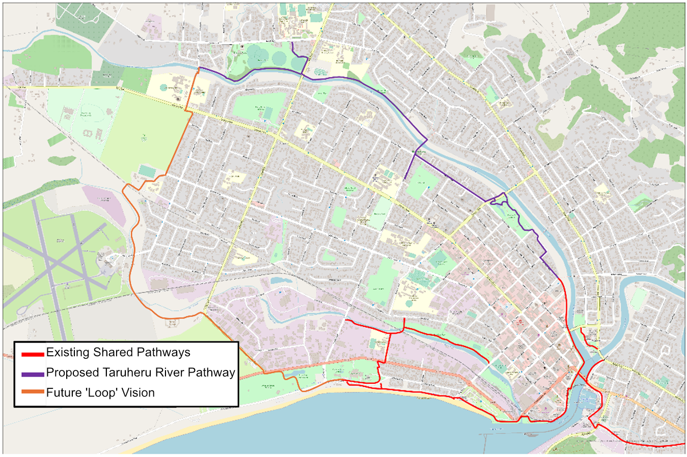
A connected city for the future
The Taruheru River Pathway is part of a wider vision for a connected city loop - making it easier to move between suburbs, schools, parks and the city centre.
The pathway will provide a safer, more affordable way to travel, supporting community wellbeing and making it easier to get around without relying on a car.
The map below shows what this future could look like.
Map of existing, proposed and future pathways